

FlySight tracks, terrain profiles and community beta can reveal a huge amount about a BASE jump. But what can the data really tell you, and where does judgement still take over?
FlySight tracks, laser profiles, approach tracks, videos and community beta can tell you an incredible amount about a BASE jump before you ever stand at the exit. But more information does not automatically make the decision for you. So how should all that data actually be used?
Imagine you are looking at a BASE exit you have never jumped before.
There is a FlySight track from someone who has flown it. Someone else has uploaded a terrain profile. You can see the approach on a 3D map, watch videos of previous flights, check trip reports and perhaps even compare several different starts against the shape of the mountain.
Compared with relying on a few photos and somebody telling you "yeah, it goes", that feels like a pretty substantial improvement.
But there is an interesting problem hidden inside all of that information.
At what point does having more data help you make a better decision, and at what point does it simply make it easier to convince yourself that the answer is yes?
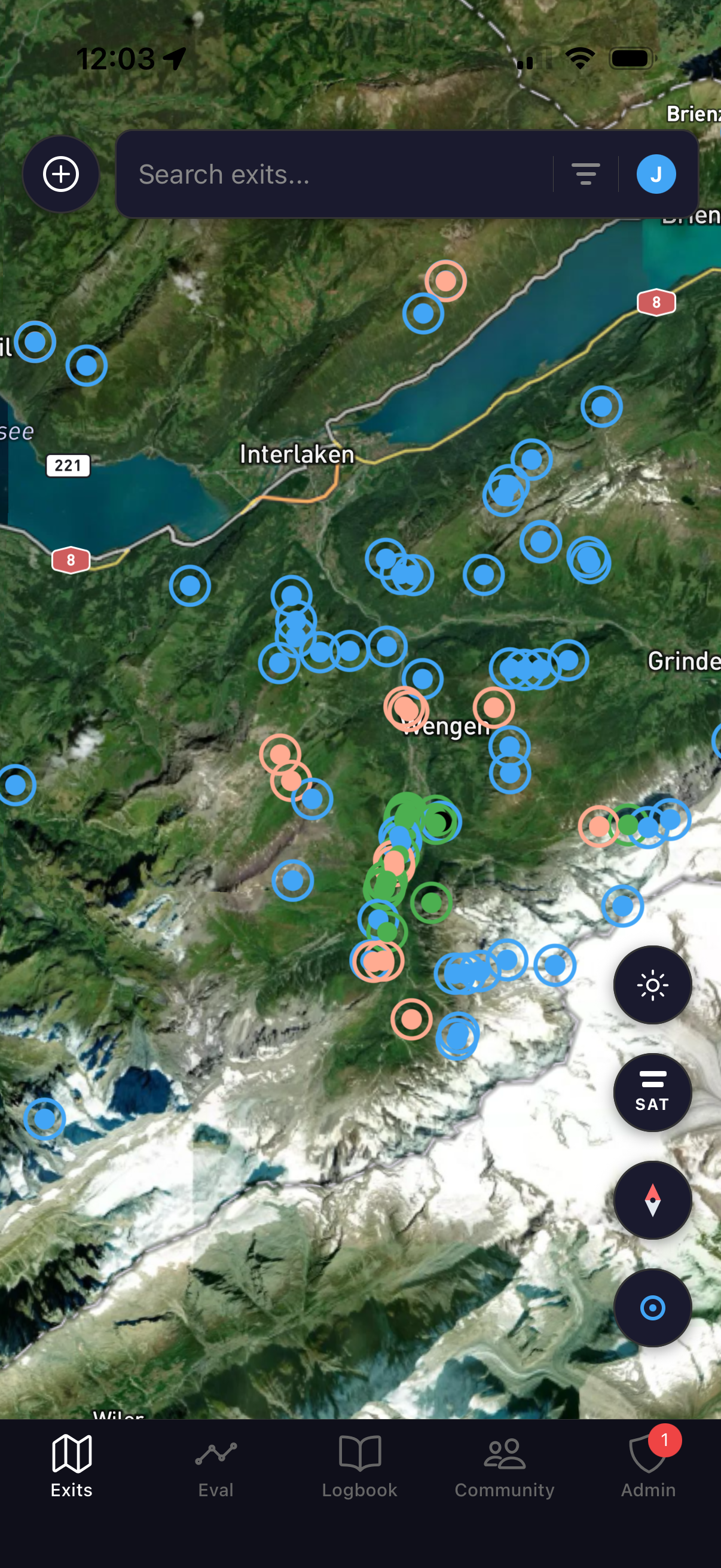
I recently sat down with JJ Bruno for an episode of the Leading Edge podcast (coming very soon). JJ is the person behind ExitEval, a project that brings many of these separate pieces of information together, from FlySight data and laser profiles through to exit beta, approaches and previous flights.
Now, I don't BASE jump, so I am certainly not going to pretend this is my guide to deciding whether you should jump from a particular cliff.
What caught my attention was something slightly different.
I spend a lot of time looking at progression, flight data and how wingsuiters make decisions, and JJ's approach to evaluating a jump raised some really interesting questions about what data is actually good for.
Because the more we spoke, the clearer one thing became:
The value of the data is not that it tells you whether to jump. It is that it allows you to question your assumptions before you do.
Start with what actually happened, not what you remember happening
One part of JJ's process that I particularly liked happens after the jump rather than before the next one.
Once he has landed and stashed, he will often import the FlySight track while the flight is still fresh in his head.
That gives him an opportunity to compare two versions of the same jump: what he thought he did and what the data says he actually did.
Those two things are not always the same.
You might come away from a flight thinking you had gradually built energy throughout the start, only for the FlySight data to show that you were sacrificing more speed for glide than you realised.
Equally, something that felt relatively flat may turn out to have involved much more diving and acceleration than you thought.
That does not automatically make either flight good or bad. The useful part is finding out whether your intention matched reality.
For me, that is one of the most valuable uses of flight data in general.
It is very easy to become confident in what we think we are doing. Data gives you another reference point.
If the two repeatedly disagree, that is probably worth understanding.
One number cannot tell you whether a start was good
This is where it becomes tempting to chase metrics. ExitEval gives you several ways of looking at the beginning of a flight.
First 1:1 is the point at which your horizontal speed equals your vertical speed. It gives you a consistent way of approximating when the suit has begun to fly at a 1:1 glide ratio.
There is also 40x, which looks at how much vertical altitude you have used by the time you have moved 40 metres horizontally.
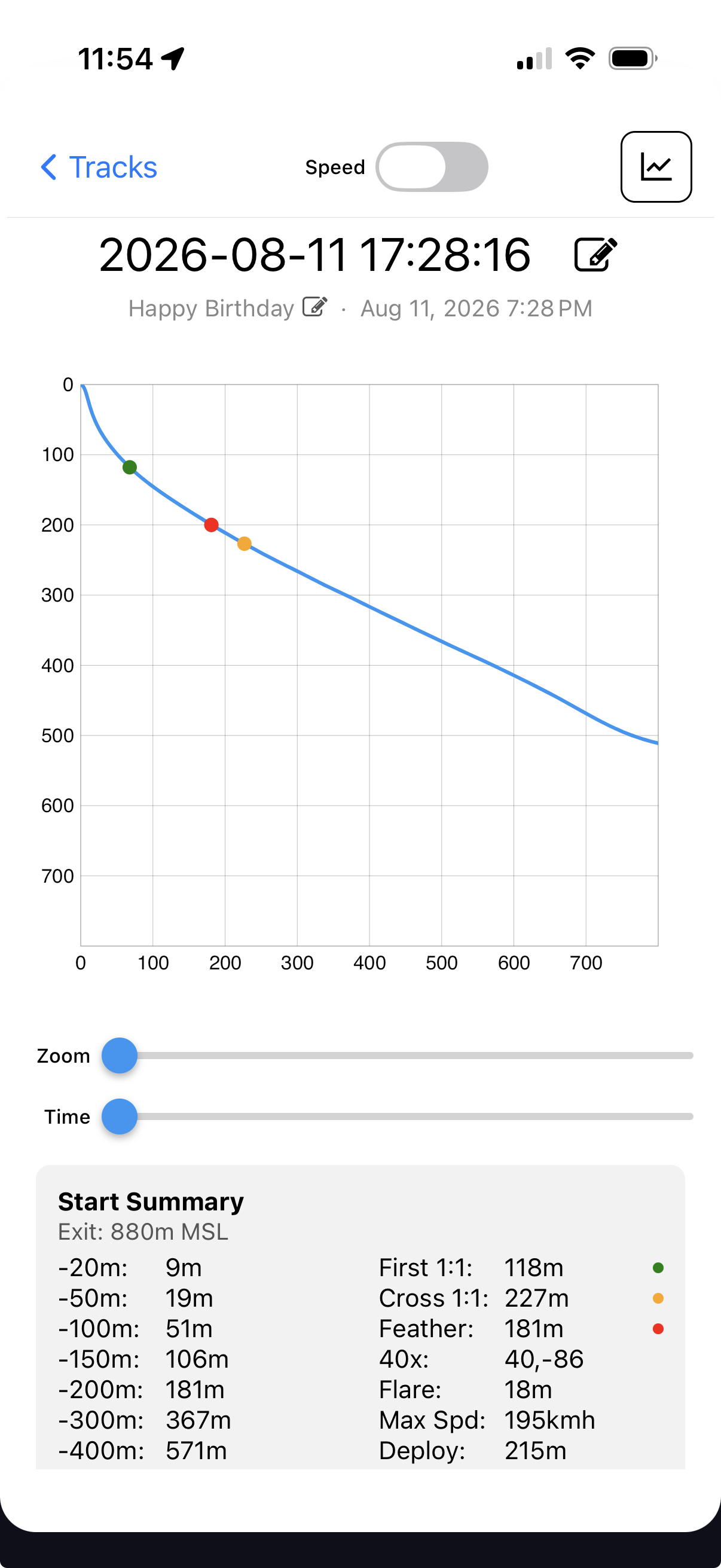
And then there is cross 1:1. Imagine drawing a 45-degree line down from the exit. Cross 1:1 is the point at which the flight crosses that line.
All useful measurements.
But none of them means very much without understanding what the pilot was actually trying to do.
JJ used cross 1:1 as a good example of this. If one flight crosses at 230 metres and another at 250 metres, it is very easy to decide that 230 must be the better start.
But what did you trade to achieve it?
Were you trying to start at a higher glide?
Were you deliberately building speed?
What did the terrain require?
What did your horizontal speed look like several seconds later?
A lower number may represent a better start for one flight and completely the wrong strategy for another.
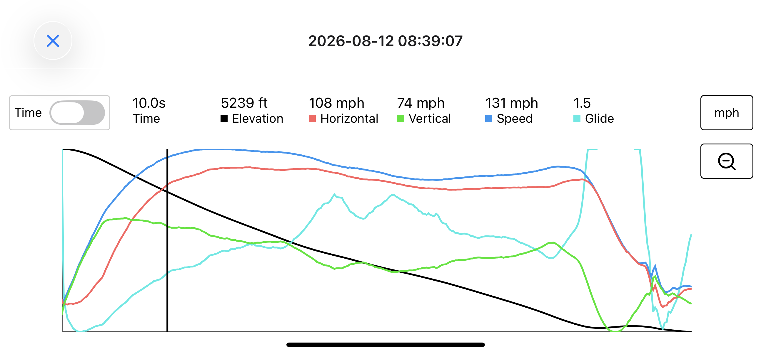
That is why JJ will move from the start metrics into the time graph and look at how the flight actually developed.
The number gives you a reference, the rest of the flight gives it meaning.
Energy matters more than winning the graph
This is probably the danger whenever we start measuring anything in wingsuiting.
As soon as you give something a number, somebody will try to beat it.
We see the same thing in performance flying. Glide, speed and distance are useful because they allow us to measure what happened. But if you start chasing one number without considering what you are giving up elsewhere, the metric can quickly become the goal rather than a tool.
JJ looks at the relationship between horizontal speed, vertical speed, total speed and glide throughout the flight.
If a higher glide has come at the cost of a substantial reduction in speed, that tells you something very different from a flight where glide increased while energy remained relatively strong.
Again, there is not one perfect graph.
Terrain changes what you need, conditions change what is available, the line you intend to fly changes the objective.
What matters is understanding the trade you made rather than simply congratulating yourself because one metric improved.
Your worst tracks may be more useful than your best ones
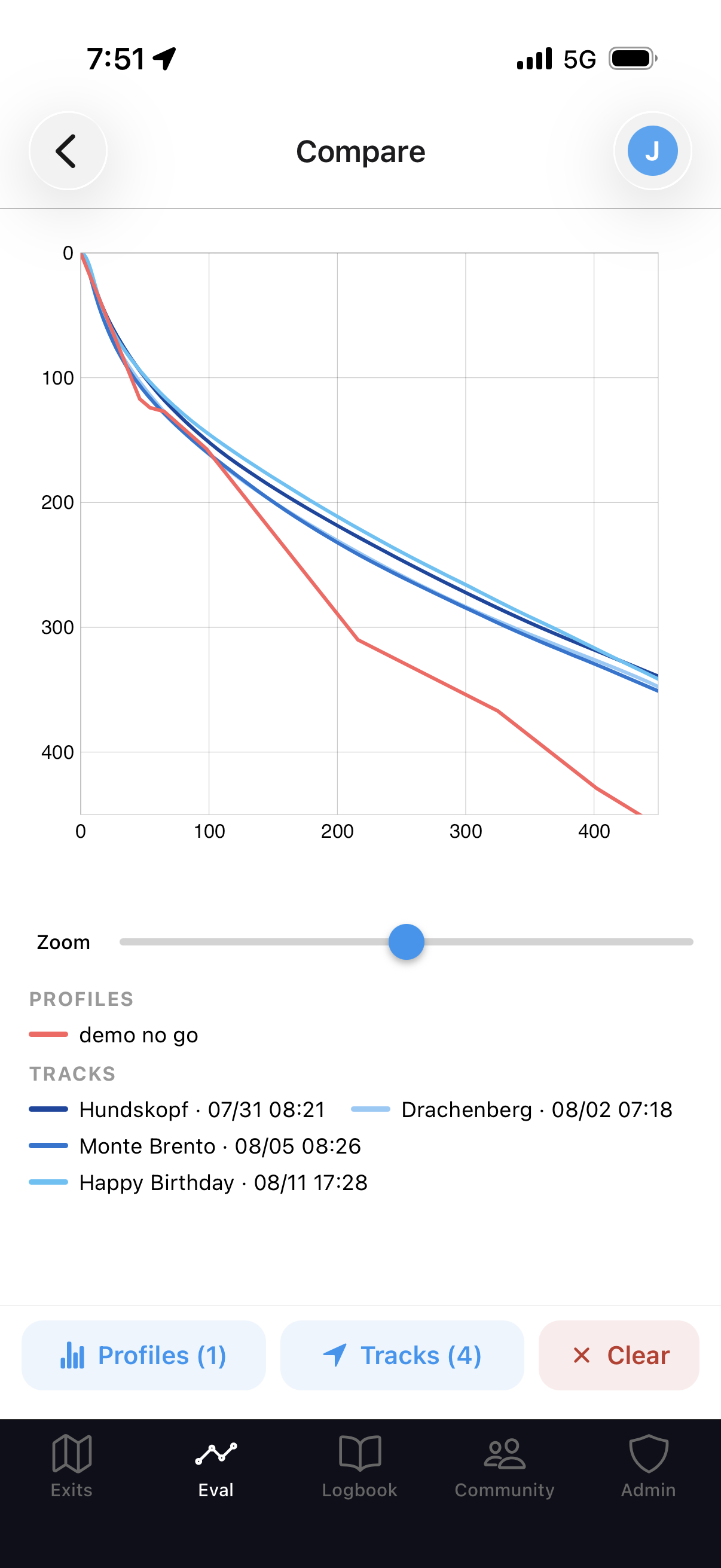
Once you have several FlySight tracks, ExitEval allows you to overlay them against a terrain profile.
And this is where JJ said something I think is particularly important.
He deliberately keeps some bad starts.
That sounds obvious once someone says it, but think about how easy it would be to do the opposite.
You are looking at a new exit. You find the cleanest start you have ever produced in that suit, place it over the terrain and everything looks lovely.
Technically, you have used your own data, but have you actually learnt anything useful?
JJ prefers to compare several flights rather than cherry-picking the one that makes the terrain look comfortable. Some of those are deliberately starts he would not consider particularly good.
Because if you are trying to understand your margin, surely your less impressive performances matter just as much as your best one.
Probably more.
There is also a much less comfortable thought sitting behind this:
- You may not have had your worst exit yet.
- Your previous tracks show you what has happened.
- They cannot tell you what will happen next.
So if an exit only works on paper when you overlay your absolute best performance, that should probably create more questions rather than more confidence.
The terrain profile tells you where the real problem is
It is also easy to simplify an exit into one big number.
How high is it?
How much rock drop is there?
How far out do I need to be?
But the shape of the terrain matters just as much as the overall size of it.
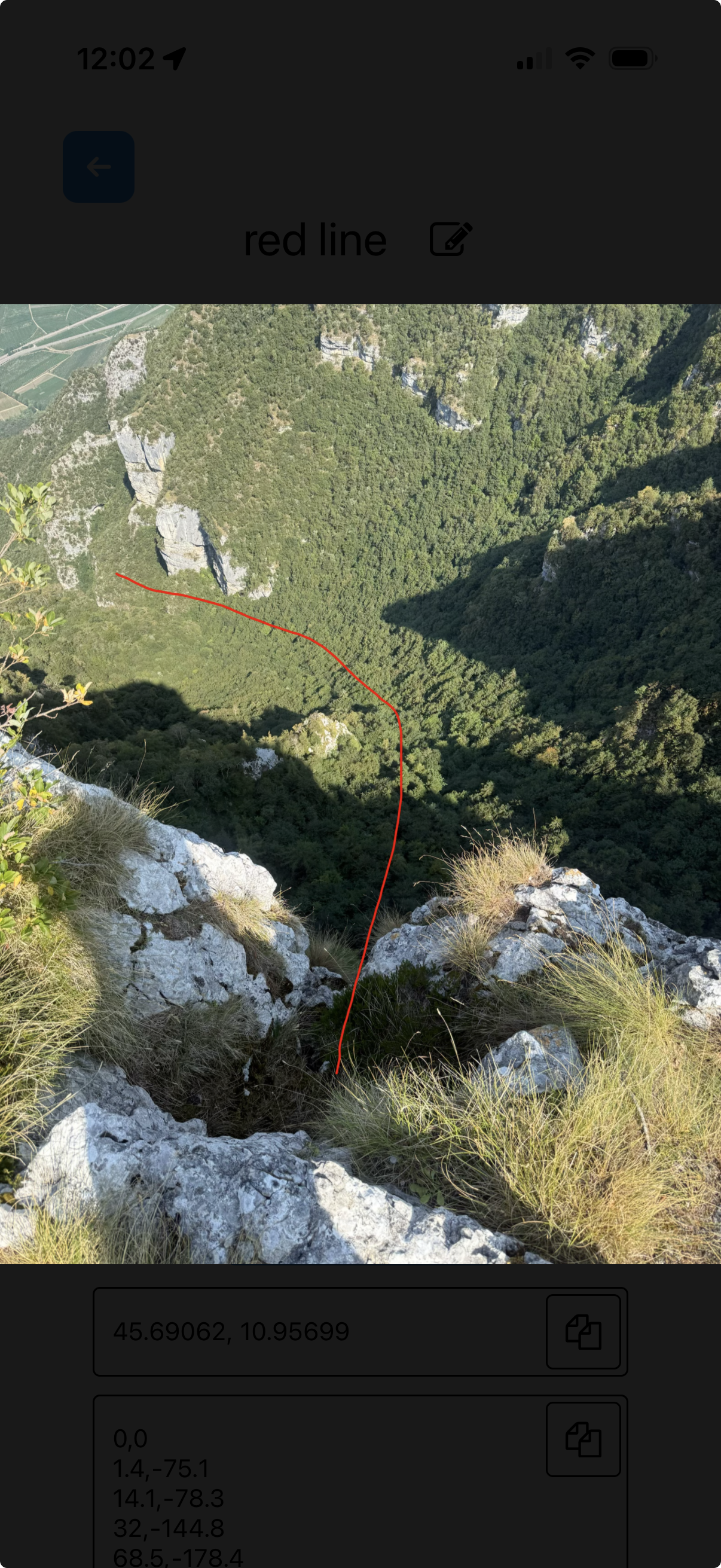
ExitEval allows a laser profile of the terrain to be plotted alongside previous FlySight tracks. JJ commonly uses a Bluetooth laser to create a series of horizontal and vertical measurements, building a side profile of what is actually below and ahead of the exit.
He will normally photograph the exit as well and draw approximately where he took the laser measurements so that the profile still has context when he returns to it later.
What I found interesting here is how different two exits can be even when the headline numbers sound similar.
One may have an obstacle relatively early in the start before opening significantly.
Another might give you much more space initially but gradually bring the terrain back towards the flight path later. The crux can occur almost anywhere.
That means "I've flown a 300-metre cliff before" is not necessarily a very useful comparison.
You need to understand where the mountain demands something from you, not simply how big the mountain is.
Comparing tracks only works if the comparison makes sense
There is another trap with having access to lots of data, more tracks do not necessarily mean better information.
JJ is quite deliberate about trying to compare flights made in broadly relevant conditions.
Time of day can matter, aspect can matter, elevation can matter.
The type of exit can matter, particularly whether you can get the same sort of push.
And, of course, what the air was doing can change the entire flight.
A track made in unusually helpful conditions might look fantastic. That does not make it a particularly sensible track on which to build your expectations for another day.
JJ actually records conditions alongside his jumps so that when he looks back at a flight months later, there is some context around what he is seeing.
I think there is a useful principle in that.
Favourable conditions can increase your margin. They should not be the reason the margin exists.
Otherwise you are not really evaluating your own performance. You are evaluating your performance plus an assumption about what the air will give you.
A map full of exits is still only beta
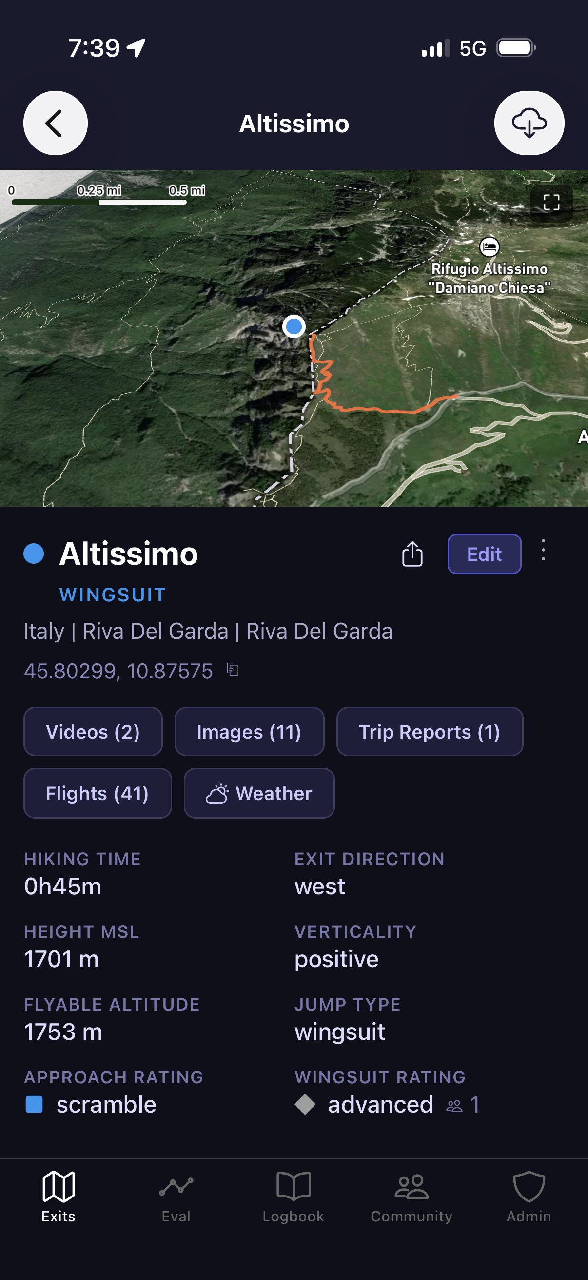
ExitEval also includes a large map of BASE exits.
Depending on what has been contributed, an individual exit might have videos, images, FlySight tracks, an approach route, terrain profiles, trip reports, weather information and user-generated difficulty ratings.
There are some clever tools around that information as well. You can look at an exit and approach in 3D, export an approach GPX and even use the sun-angle feature to get an idea of when the exit or line may move into sunlight.
From an information point of view, it is pretty impressive.
But JJ is also very clear about the limitations, this is community-generated beta.
Some exits have a lot of information behind them. Others may have an approximate pin and very little else.
A verified flag means a trusted user has jumped that exit. It does not mean somebody else has completed the evaluation for you.
JJ's advice where there is limited beta is essentially to treat the exit as though you were opening it yourself: work out the approach, find the exit, laser what you need to laser and establish whether you are personally comfortable with what is there.
Particularly for newer jumpers, an exit with substantial, well-established information behind it is obviously a very different proposition from a dot on a map.
The map helps you find the information.
It does not remove your responsibility to verify it.
The useful part of community beta is what happens after your jump
This was another part of the project I really liked.
The information becomes more useful when the people consuming it also contribute something back.
After a jump, you can add a trip report explaining something that might help the next person. Perhaps there is an easy-to-miss turn on the approach. Perhaps a rope is damaged. Perhaps the conditions were doing something worth noting.
You can contribute a FlySight track, you can add your own interpretation of the difficulty.
Over time, that begins to build something far more useful than a static list of exit coordinates.
JJ also encourages people to share their FlySight tracks where appropriate so that another jumper looking at the exit does not have to base their understanding on one person's flight.
There is an important community element in that.
For years, huge amounts of knowledge in wingsuiting and BASE have lived in private messages, conversations at the bottom of mountains and the heads of a relatively small number of people.
Some of that will always be the case, and there are obviously exits where information needs to remain sensitive.
But where information can responsibly be preserved, there is a lot of value in doing it.
JJ also credits Brendan Weinstein and the work that went into the original BaseBeta exit dataset, which became the foundation from which much of the map could be built.
That is years of community knowledge that has not simply disappeared.
This is the sort of project I want to see more of
I think this is probably why ExitEval caught my attention in the first place.
Not because I am suddenly planning to start BASE jumping, I'm not.
It is because somebody within a fairly small community saw a collection of things people were already doing separately and decided to invest the time into bringing them together.
FlySight analysis already existed, people already laser exits, people already compare tracks, save approach routes, exchange beta and discuss conditions.
ExitEval has tried to organise those pieces into something that can be learnt from and contributed back to.
I have a lot of time for projects like that.
Leading Edge ultimately comes from a similar motivation. There is an enormous amount of knowledge within wingsuiting, but that knowledge is only really useful to the wider community if people are prepared to share it, challenge it, preserve it and build on it.
That does not mean every community project is automatically perfect.
It means I think people willing to put time into creating useful resources for a relatively small sport deserve support and, importantly, constructive input from the people actually using them.
That is how these things improve.
So, what can data actually tell you about a BASE jump?
Quite a lot.
It can show you what your previous starts actually looked like rather than what you remember them looking like.
It can help you compare several performances rather than relying on one good flight.
It can show you where the terrain begins to become relevant.
It can give you context from previous jumpers and help you understand approaches, conditions and potential lines.
And it can expose the difference between what you intended to do and what you actually did.
What it cannot do is tell you that you are safe.
It cannot guarantee that tomorrow's start will match yesterday's.
It cannot guarantee that the conditions will behave as expected.
It cannot decide whether the margin on the screen is enough for you.
And it certainly cannot turn somebody else's successful track into your own ability.
Perhaps that is the best way to look at ExitEval, and flight data more generally.
The aim should not be to collect enough information that the uncertainty disappears.
It should be to understand the uncertainty better.
Because if all that extra data simply makes you more confident, you may have missed the point.
If it makes you ask better questions, compare more honestly and challenge the assumptions you were already making, then it is probably doing something genuinely useful.
More data should not make the decision for you. It should make you better informed when you make it.
Check out the podcast with JJ Bruno Surfers vs Scientists, Reading the Start Arc, and the Craft of Trusting Your Data
Other things worth reading.


Want this kind of thinking, monthly?
New episodes, field notes and event drops. One email a month. No marketing fluff, no hype.